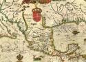
In the Age of Discovery, maps held closely guarded secrets for the kings, adventurers, and merchants who first acquired them.


Discover the most detailed periodic table in the world. The World of Elements organizes every known element into a visual masterpiece, showcasing their unique properties, uses, and historical significance. Perfect for science lovers and curious minds.
- 48" x 28" -- $130
- 60" x 34" -- $160
- 68" x 40" -- $190

A touch of history
Browse historical places and
search for old maps with timeline.

There doesn't seem to be a way to do this specifically (possibly because you can't even see the speed limit on the web app outside of photographs — only on the mobile apps proper), so you'll just have to use the form to report a generic problem with a road:
Open the left sidebar hamburger menu
- "Edit the map"
- "Add or fix a road"
- Click on the road
- Select the appropriate "Length of road"
- Underneath that, select "Other" and type in a description of what needs to change
OurAirports is a free site where visitors can explore the world's airports, read other people's comments, and leave their own. The help pages have information to get you started.
The site is dedicated to both passengers and pilots. You can create a map of the airports you've visited and share that map with friends. You can find the closest airports to you, and discover the ones that you haven't visited yet.
Behind the fun and features, OurAirports exists primarily as a public good. When Australia forced the US government to shut down public access to its Digital Aeronautical Flight Information File (DAFIF) service in 2006, there was no longer a good source of global aviation data. OurAirports started in 2007 primarily to fill that gap: we encourage members to create and maintain data records for airports around the world, and they manage over 40,000 of them. Many web sites, smartphone apps, and other services rely on OurAirport's data, which is all in the Public Domain (no permission required).

I was wondering the difference between WGS84 and EPSG:4326 (see this).
Can then WGS84 on its own be defined as a Coordinate Reference System? Or is it just a datum so that a Coordinate System must be attached to it to fully define a CRS? (see e.g. this document, figure below Sec. 6.4.1)
ANSWER:
There can be some confusion over the difference between a Spatial Reference System (SRS) and a Coordinate Reference System (CRS), and unfortunately WGS84 is often used for both. EPSG:4326 is merely the reference number of EPSG's database entry describing a CRS. Typing 4326 into their website here gives us this:
enter image description here
The things to note here are that 4326 refers to a Geodetic CRS (i.e. it uses latitude and longitude as coordinate units). It is made up of the WGS84 Geodetic Datum (EPSG:6326) and an ellipsoidal coordinate system (EPSG:6422). The datum itself is made up of the WGS84 ellipsoid, and a prime meridian. These are the SRS components.
So you can see in this instance, WGS84 could refer to three different things! But EPSG:4326 is unambiguous. The beauty of this system is that other geodetic CRSes can be defined in terms of EPSG:6422 (Ellipsoidal CS) and we'd always know it refers to an North/East longitude/latitude coordinate system.
In addition, projections can be built up from these geodetic CRSes, for instance UTM zone 30N looks like this:
enter image description here
Here you can see that it uses the WGS84 CRS as its base coordinate reference system, then defines the type of projection, its origin, and its false eastings and northings. So it can be viewed as a kind of "wrapper" around EPSG:4326, which is already well defined. It would be possible, for instance, to use the same projection parameters but a different geodetic CRS such as OSGB 1936 (EPSG:4277), which will define a valid coordinate system but one that would be of less use to other users. These sort of ad-hoc CRSes tend to be given high EPSG numbers, and often are just bogus ones invented for a specific use and not officially adopted by the EPSG. EPSG:900913 (Google's Web Mercator) was like this, until it was adopted as EPSG:3857.
-
Google Earth is in a Geographic coordinate system with the wgs84 datum. (EPSG: 4326)
-
Google Maps is in a projected coordinate system that is based on the wgs84 datum. (EPSG 3857)
-
The data in Open Street Map database is stored in a gcs with units decimal degrees & datum of wgs84. (EPSG: 4326)
-
The Open Street Map tiles and the WMS webservice, are in the projected coordinate system that is based on the wgs84 datum. (EPSG 3857)
So if you are making a web map, which uses the tiles from Google Maps or tiles from the Open Street Map webservice, they will be in Sperical Mercator (EPSG 3857 or srid: 900913) and hence your map has to have the same projection.
I'll like to expand the point raised by mkennedy
All of this further confused by that fact that often even though the map is in Web Mercator(EPSG: 3857), the actual coordinates used are in lat-long (EPSG: 4326). This convention is used in many places, such as:
- In Most Mapping API,s You can give the coordinates in Lat-long, and the API automatically transforms it to the appropriate Web Mercator coordinates.
- While Making a KML, you will always give the coordinates in geographic Lat-long, even though it might be showed on top of a web Mercator map.
Create and publish interactive maps
Use maps for analysis and presentations
Unlimited markers per map.
3-level access control for each map: Viewer, Member and Admin
Input from: Location(Search), Crowd Source, Google Spreadsheets, Microsoft Excel, CSV, KML, GeoRSS feed or Copy-and Paste.
A few years ago, online sleuths found an image of a B-2 stealth bomber in flight over Missouri. The aircraft is smeared in the image because it was in motion, while the farm fields below appear as crisp as any other view on Google Earth. https://petapixel.com/2021/12/28/stealth-bomber-caught-mid-flight-in-a-google-maps-photo/
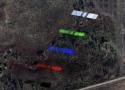
There's something else that now appears on Google Earth. Zoom in over rural North Texas, and you'll find a satellite. It appears five times in different colors, each projected over wooded bottomlands in a remote wildlife refuge about 60 miles (100 kilometers) north of Dallas.
The Prime Meridian is the universally decided zero longitude, an imaginary north/south line which bisects the world into two and begins the universal day. The line starts at the north pole, passes across the Royal Observatory in Greenwich, England, and ends at the south pole. Its existence is purely abstract, but it is a globally-unifying line that makes the measurement of time (clocks) and space (maps) consistent across our planet.
The Greenwich line was established in 1884 at the International Meridian Conference, held in Washington DC. That conference's main resolutions were: there was to be a single meridian; it was to cross at Greenwich; there was to be a universal day, and that day would start at mean midnight at the initial meridian. From that moment, the space and time on our globe have been universally coordinated.
Having a single prime meridian brings to the world's cartographers a universal map language allowing them to join their maps together, facilitating international trade and maritime navigation. At the same time, the world now had one matching chronology, a reference by which today you can tell what time of day it is anywhere in the world simply by knowing its longitude.
CH] Weisshorn (VS)
latitude 46.101389 N longitude 7.716111 E
elevation 14781 ft above sea level (14781 ft above ground)
Help anyone give you their current what3words address with this link: http://locate.what3words.com
Useful for people who struggle with technology
With a click of the link, the recipient’s current what3words address is displayed on their screen, allowing them to easily share their exact location by copying the words into a message, or speaking them over the phone.
Works in areas with poor data connection
The web page has been designed to have a low data requirement of just 25KB, so it should load even in places where you don’t have much data available.
The Terminal Procedures Search application allows searching, viewing, and downloading of the U.S. Terminal Procedure Publications (TPPs) as PDF files
Experience may matter more than innate ability when it comes to sense of direction. //
“People are never perfect, but they can be as accurate as single-digit degrees off, which is incredibly accurate,” says Nora Newcombe, a cognitive psychologist at Temple University who coauthored a look at how navigational ability develops in the 2022 Annual Review of Developmental Psychology. But others, when asked to indicate the target’s direction, seem to point at random. “They have literally no idea where it is.”
Personality, too, appears to play a role in developing navigational ability. “To get good at navigating, you have to be willing to explore,” says Uttal. “Some people do not enjoy the experience of wandering, and others enjoy it very much.”

See current wind, weather, ocean, and pollution conditions, as forecast by supercomputers, on an interactive animated map. Updated every three
all the tags from https://b.plas.ml
1st-amendment 2nd-amendment 4th-amendment 5th-amendment 9/11 a8 abortion acl adhd afghanistan africa a/i air-conditioning amateur-radio amazon america american android animals anti-americanism antifa anti-semitism antiv antivirus aoip apollo apple appliances archaeology architecture archive art astronomy audio automation avatar aviation backup bash batteries belleville bible biden bill-of-rights biology bookmarks books borg bush business calibre camping capitalism cellphone censorship chemistry children china christianity church cia clinton cloud coldwar communication communist composed computers congress conservatives constitution construction cooking copyleft copyright corruption cosmology counseling creation crime cron crypto culture culture-of-death cummins data database ddt dd-wrt defense democrats depression desantis development diagrams diamonds disinformation diy dns documentation dokuwiki domains dprk drm drm-tpm drugs dvd dysautonomia earth ebay ebola ebook economics education efficiency electricity electronics elements elwa email energy engineering english environment environmentalism epa ethernet ethics europe euthanasia evolution faa facebook family fbi fcc feminism finance firewall flightsim flowers fonts français france fraud freebsd free-speech fun games gardening genealogy generation generators geography geology gifts git global-warming google gop government gpl gps graphics green-energy grounding hdd-test healthcare help history hollywood homeschool hormones hosting houses hp html humor hunting hvac hymns hyper-v imap immigration india infosec infotech insects instruments interesting internet investing ip-addressing iran iraq irs islam israel itec j6 journalism jumpcloud justice kindle kodi language ldap leadership leftist leftists legal lego lgbt liberia liberty linguistics linux literature locks make malaria malware management maps markdown marriage mars math media medical meshcentral metatek metric microbit microsoft mikrotik military minecraft minidisc missions moon morality mothers motorola movies mp3 museum music mythtv names nasa nature navigation navy network news nextcloud ntp nuclear obama ocean omega opensource organizing ortlip osmc oxygen paint palemoon paper parents passwords patents patriotism pdf petroleum pets pews photography photo-mgmt physics piano picasa plesk podcast poetry police politics pollution pornography pots prayer pregnancy presentations press printers privacy programming progressive progressives prolife psychology purchasing python quotes rabbits rabies racism radiation radio railroad reagan recipes recording recycling reference regulations religion renewables republicans resume riots rockets r-pi russia russiagate safety samba satellites sbe science sci-fi scotus secularism security servers shipping ships shooting shortwave signal sjw slavery sleep snakes socialism social-media software solar space spacex spam spf spideroak sports ssh statistics steampowered streaming supplement surveillance sync tarsnap taxes tck tds technology telephones television terrorism tesla theology thorium thumbnail thunderbird time tls tools toyota trains transformers travel trump tsa twitter typography ukraine unions united.nations unix ups usa vaccinations vangelis vehicles veracrypt video virtualbox virus vitamin vivaldi vlc voting vpn w3w war water weather web whatsapp who wifi wikipedia windows wordpress wuflu ww2 xigmanas xkcd youtube zfs